1 hr 45 min
By car from the Public Square, 89 miles, with no traffic
Day trip · Warren County
Rock Island is an hour and 45 minutes from the Public Square: two waterfalls, a limestone gorge you can climb down into, a brick cotton mill from 1892 and a sand beach at the head of Center Hill Lake. Whether you get the gorge depends on Great Falls Dam, which sits just upstream and belongs to TVA. Here is how the water works, how to check it the night before, what is open in November, and the rules the state enforces below the powerhouse.
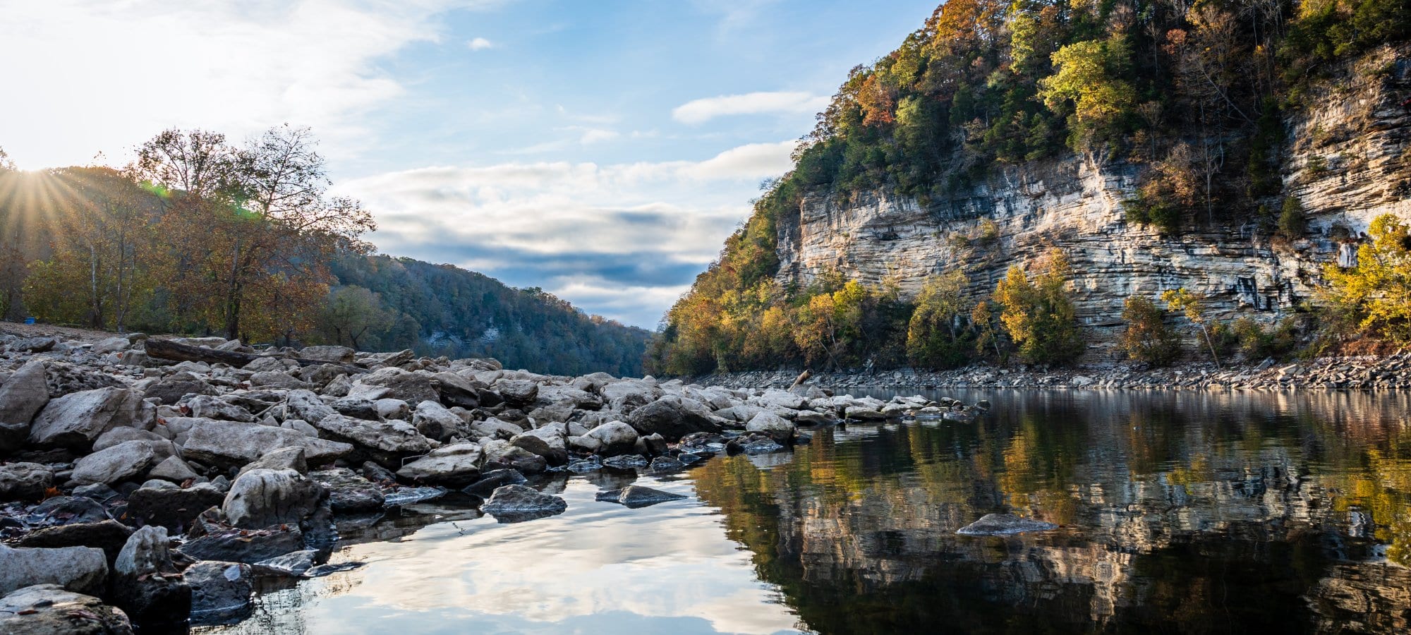
Rock Island State Park is in Warren County, where the Collins, Rocky and Caney Fork rivers meet at the head of Center Hill Lake. From the Public Square it is 89 miles and about an hour and 45 minutes by car: Highway 96 to I-840, I-24 east to Murfreesboro, then US 70S through Woodbury and McMinnville. Entry is free, and the park is open from 7 a.m. to 10 p.m., though some areas close earlier.
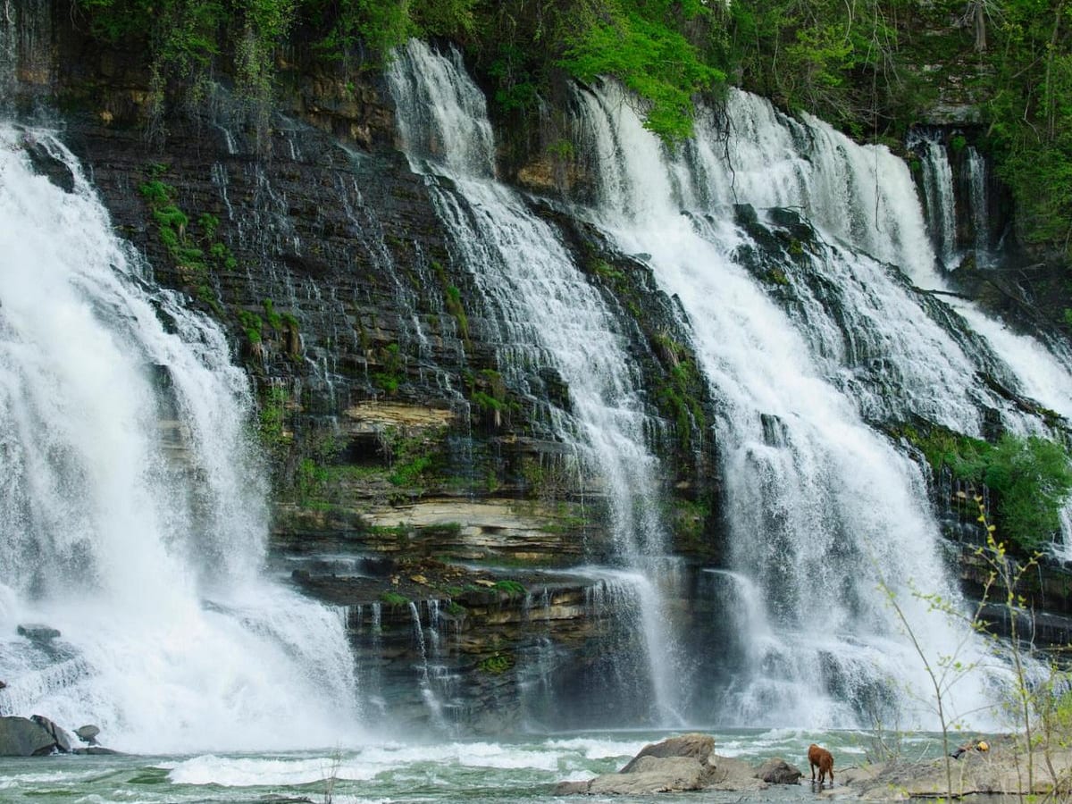
What people drive out for is the water. Twin Falls pours out of a limestone bluff into the Caney Fork. The Great Falls drops 30 feet beneath a brick cotton mill from 1892. Between the two runs a gorge of ledges and pools you can climb down into, and below them the park has a sand beach, ten cabins and a campground.
The gorge belongs to the river, and the river belongs to TVA. Great Falls Dam sits just above the falls, and whenever it is spilling water, or a release is likely that day, the state closes the gorge. Releases follow the weather and the power grid, and the schedule can change by the hour. So the first thing to do before you drive is read TVA's page, which section 03 walks through. The rest of this piece covers the falls, the trails, where you may swim and where you may never swim, the cabins and campground in winter, and how a mill town turned into a state park.
Great Falls Dam is 92 feet high and 800 feet across, a short way above the waterfall it is named for. TVA says the Tennessee Electric Power Company finished it in 1916 and that TVA bought it in 1939. It is one of seven dams TVA bought from private companies, and the only one it runs outside the Tennessee River's watershed.
The dam does not make its electricity at the dam. Its turbines take water out of the Collins River arm of the lake and send it through tunnels and steel penstocks cut through the ridge, to a powerhouse on the Caney Fork side of the peninsula where the two rivers meet. TVA's own history of the plant says the generators pull hard enough that the Collins can briefly run backward. That leaves the lake two ways out. Water sent through the powerhouse goes around the gorge and comes out below it. Water let over the dam's 18 crest gates goes over the Great Falls and down through the gorge.
The state's rules follow the plumbing. The powerhouse "typically releases water at some point every day at irregular times," the park's safety page says, so swimming and wading below it are banned all the time, release or not. The gorge above it, the half mile between the dam and the powerhouse, is closed whenever the dam is spilling or a discharge is likely that day. The park says access depends on TVA's hourly predictions, and that a closure can come without notice and last any length of time.
On the evening of November 11, TVA's page for Great Falls showed no generation scheduled that day or the next, 160 cubic feet of water a second leaving the dam, and the lake at 787.37 feet, about 18 feet below the top of the gates at 805.3. That is what a quiet day looks like on the page. Even then, the park decides on TVA's word whether the gorge is open, and posts it on its Facebook page.
A closed gorge still has something to see. Damon Graham, the park's manager, told UCNow in May 2025 that a large release is worth watching from the overlooks just below the dam, which stay open when the gorge does not.
TVA publishes the dam's schedule three ways.
TVA updates the schedules through the day, and says the next day's is usually up by 6 p.m. Its predicted lake levels are refreshed by 1 p.m. Eastern. Check the night before, again in the morning, and once more at the visitor center at 82 Beach Road, which keeps 8 a.m. to 4 p.m. and whose staff know the day's releases. Do the checking before you go down: the park says cell service is limited in the gorge, at the Blue Hole and at Sandbar Beach.
In the gorge, the park's rule is short. If you hear a siren, or see the water rising or turning muddy, get out and stay on higher ground. In an emergency, call 911, say you are in the Caney Fork River Gorge at Rock Island State Park, and give your position from the powerhouse or the cotton mill.
The Great Falls is a 30-foot horseshoe of limestone on the Caney Fork just below the dam, under the mill. How much water goes over it depends on what TVA lets out. Below it the gorge runs down to the powerhouse, a bed of ledges and pools that people come to rock-hop, swim and fish. The park's swimming page names two pools in it: the Cold Hole, which it calls the gorge's best swimming hole, and the Warm Hole, a wide, shallow basin warmed by the sun and spared the cold water that comes off the lake.
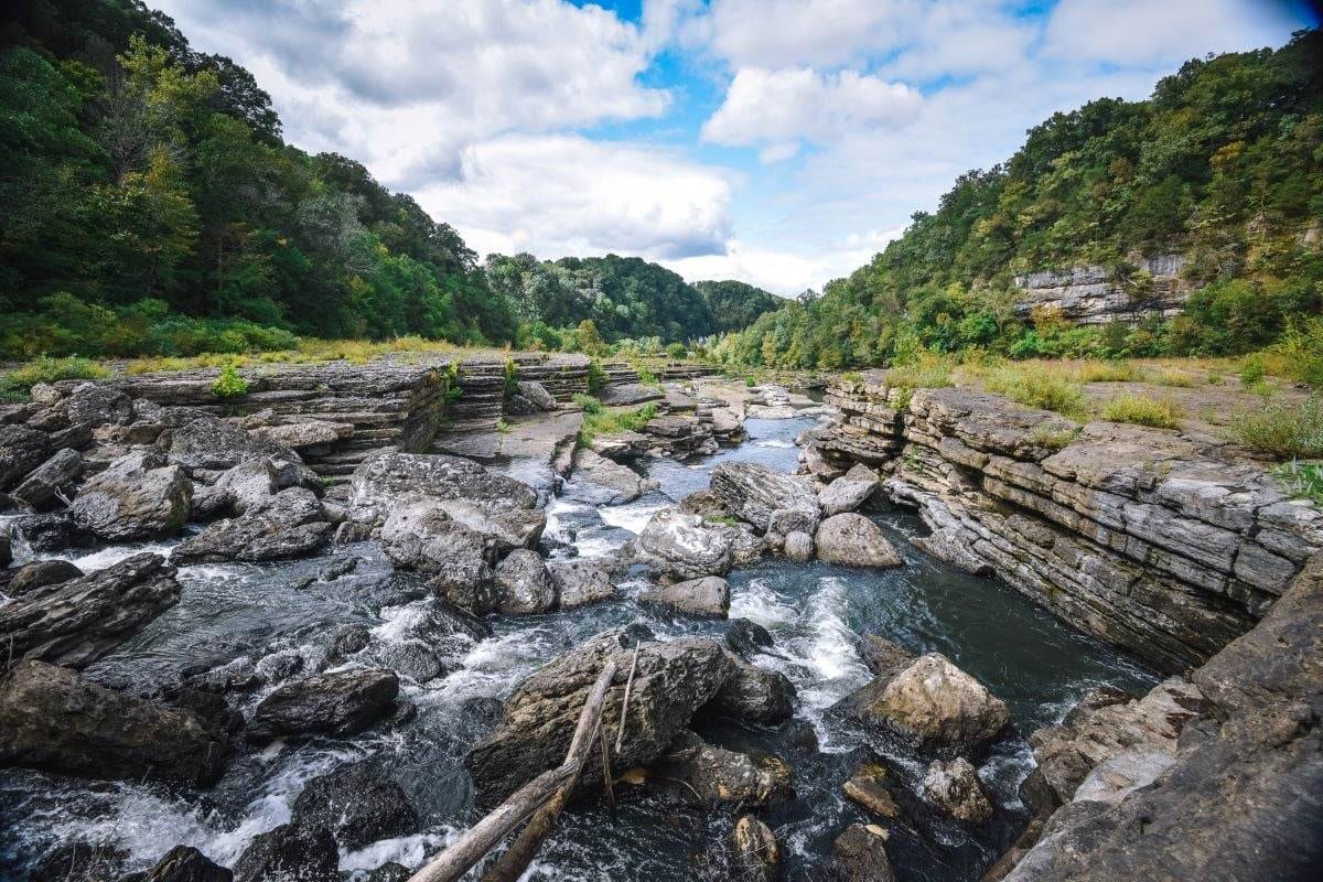
Two trails go down. The Old Mill Gorge Trail, a tenth of a mile, leaves the Old Mill picnic area by staircases, and the state calls it steep, wet and rocky. The Upstream Trail, two tenths of a mile, starts at the Twin Falls Overlook at the end of Powerhouse Road. It is still strenuous, but the climb back out is less steep, and its large lot often has room when the Old Mill lot is full. Both trails and both lots close at sundown from November through March and at 6 p.m. from March through November. Children 12 and under need an adult with them, and coolers, glass, strollers and alcohol are not allowed in the gorge.
Twin Falls is the park's tallest waterfall, 80 feet by the state's count. It comes out of the bluff across the river from the overlook, water from the Collins River that has found its way through the limestone, and falls into the Caney Fork. The state's pages do not say when it began. The account usually given, on Wikipedia among other places, is that it appeared after the dam raised the Collins, and the 1990 National Register nomination for the dam notes that TVA had to fix leaks through the peninsula after it bought the plant. There is no trail to its base. You see it from the overlook, which has parking, benches and a kiosk.
Farther down, past the powerhouse, the Blue Hole is a fishing spot reached by the short Blue Hole Trail or seen from above on the Downstream Trail. The park calls it the spawning ground for Center Hill Lake's walleye. Nobody swims there.
The park's hiking page lists ten trails, 8.5 miles if you add them up, though its own introduction says nine and the 2026 park brochure says 11. These are the ten the page lists, as our state parks guide recorded them on October 20.
| Trail | Miles | Difficulty | Where it goes |
|---|---|---|---|
| Old Mill Gorge Trail | 0.1 | Difficult | Staircases from the Old Mill picnic area into the gorge below the Great Falls |
| Upstream Trail | 0.2 | Difficult | From the Twin Falls Overlook into the gorge, to the Cold Hole, the Warm Hole and the Great Falls |
| Downstream Trail | 1.55 | Moderate | From the Twin Falls Overlook along the bluff, over the Blue Hole, with Twin Falls and Little Falls across the river |
| Blue Hole Trail | 0.15 | Difficult | Down to the Blue Hole, for fishing; no swimming |
| Collins River Loop Trail | 2.95 | Moderate | A wooded loop around the edge of the Collins River peninsula; a connector cuts it to two miles past two settlers' cemeteries |
| Eagle Trail | 0.75 | Moderate | An arboretum walk with the trees labeled, from the Blue Hole picnic area to Badger Flat near the beach |
| Moonshine Trail | 0.35 | Moderate | Past the base of an old moonshine still, from the tennis court lot to the campground |
| Bluff Trail | 1.95 | Moderate | A lollipop loop open to bikes, with a spur to a bench over Center Hill Lake |
| Overflow Trail | 0.3 | Not rated | The state's page gives no description |
| Cunningham Cemetery Trail | 0.2 | Easy | To the grave of John Cunningham, an Army captain in the War of 1812, and his family |
Lengths as the park's hiking page lists them. The brochure gives the Cunningham Cemetery Trail as 0.15 mile.
For a walk that does not depend on TVA, take the Downstream Trail. It leaves the Twin Falls Overlook along a steep bluff above the river, with the Blue Hole below and Twin Falls across the water. The park's ranger-led hike on it the day after Thanksgiving runs 1.6 miles there and back and climbs the equivalent of seven flights of stairs, over rocks and roots and a couple of creek crossings. There are no restrooms at that end of the park.
The longest trail is the Collins River Loop, at 2.95 miles, and it is open to mountain bikes as well as hikers. The Bluff Trail, 1.95 miles, starts at the tennis court lot, takes bikes too and is the one to walk for a view of the lake.
The beach is the easy one: a natural shore of sand and silt on the Caney Fork at the head of Center Hill Lake, below the cabins, with a boat ramp, a pavilion you can rent and restrooms. There are no lifeguards. In the gorge, the Cold Hole and the Warm Hole are open to swimmers when the gorge is.
The rest of the river is off limits. The state bans swimming and wading at Twin Falls and anywhere from the TVA powerhouse down to the main beach boat ramp, the Blue Hole included, because of currents it calls hidden and deadly. Swimming is also banned anywhere above the Great Falls, and cliff jumping and diving are banned everywhere. The park keeps some life jackets at its swimming areas and asks you to bring your own.
The rescues of the last two summers show what the rules are for. On Memorial Day 2025, nine people were rescued from the gorge after rising water trapped them, UCNow reported, quoting the park manager. On July 23, 2025, a swimmer was swept away near the powerhouse and found safe downstream, WSMV reported, and the park reminded visitors to swim only where it allows. And on July 2 this year, two kayakers overturned on the Caney Fork while the dam was releasing water. One was left on rocks in the middle of the river, and rescuers had TVA stop the release before reaching the kayaker with ropes. No serious injuries were reported.
The park's 10 cabins sit on a wooded bluff above the beach and are open all year. Each has three bedrooms, two baths and a fireplace with gas logs that run in season. The minimum stay is two nights, and can be longer on holidays. Cabins 1 and 2 take pets, at $20 a pet a night, and cabin 10 is accessible. From December 1 through February you may stay up to 28 nights in a row; the rest of the year, 14.
The main campground has 50 sites, numbered 1 to 50, for RVs and trailers, some with room for a tent. Each has 20, 30 and 50-amp power and water, six have sewer hookups, and there are two bathhouses with hot showers, a dump station and Wi-Fi. It is open all year. The tent camping area, ten sites numbered 51 to 60 with 20-amp power and water, closes every year from November 2 to March 15, so it is shut now.
Both are booked through Tennessee State Parks, online or at 1-888-867-2757, up to a year ahead, with a $5 reservation fee that is not refunded. Neither the park nor the reservation site posts a nightly rate; it appears once you pick dates. Campsites check in at 4 p.m. and out at noon.
The village of Rock Island, a little upstream of the park, was the county's first permanent settlement and for a time a county seat, the Tennessee Encyclopedia says. When the railroad came through in 1881, the village moved to the tracks, and the falls on the Caney Fork began to look like a place for a factory.
Asa Faulkner, the head of the county's largest mill-owning family, organized the Great Falls Manufacturing Company that year with his son Clay and two partners, H.L. and Jesse Walling, and had a wheel pit put in at the falls. He died on July 29, 1886. His son and the Wallings finished his mill in 1892: three stories of red brick above the Great Falls, chartered on May 5 that year with $30,000 and making 4,000 yards of sheeting a day. They built a company town, Falls City, with a post office, houses and a church where H.L. Walling preached. A flood in July 1902 carried off the mill wheel, and that month the owners sold to the Great Falls Power Company.
The dam came next. Work began in 1915, and the plant first made power in January 1917. TVA credits the Tennessee Electric Power Company with building it; the dam's 1990 National Register nomination names the Tennessee Power Company, which TEPCO took over after it was formed in 1922. A redesign in 1925 raised the dam 35 feet. TVA bought the plant in 1939, leased land to the state for a park in 1966, and Rock Island opened as a state park in 1969. Its first ranger was H.G. Deaton, the local man who had pushed for it.
The mill still stands across the road from the Old Mill picnic area and has been on the National Register since 1982. The park's 2024 management plan rates its condition critical, its grade for a resource that is badly deteriorated and needs work now, and keeps it closed to the public until Great Falls Road is rerouted around it, a bypass the state announced in February 2023. We could not confirm on November 11 that the bypass is finished, so plan on seeing the mill from outside.
Our Burgess Falls and Rock Island loop fits both parks into one eight-hour Saturday: the River Trail at Burgess Falls in the morning, lunch in Sparta, then Twin Falls and the Great Falls in the afternoon. Burgess Falls closes at 4 from November to the second Sunday in March, and the loop is through both parks by mid-afternoon all year. If TVA's schedule says the gorge will be closed, the loop still works; the overlooks become the visit.
The park has three ranger programs left this month. A free coffee with a ranger is at the Great Falls parking area at 9:30 a.m. on Saturday, November 14. Kayaking the Caney, a $6 float from the beach boat ramp, runs at 1 p.m. that day and at 11 a.m. on Monday, November 30. The free Day After Thanksgiving hike on the Downstream Trail, at 10 a.m. on November 27, was listed as sold out when we checked. Each takes registration through the events page on the park's site.
Go early. The park says it has been very busy over the past year, and that parking can be very limited. It asks visitors not to park on the roadside or anywhere unmarked, and to try another park if the lots are full. The nearest, as the crow flies, are Scott's Gulf Wilderness, Burgess Falls, Fall Creek Falls and Edgar Evins; Rock Island's page in our state parks guide lists each with its drive from Franklin.
We have not spoken to the park or to TVA for this piece. The park's rules, hours, trails and programs are what the state's pages said on November 11, 2026, and the dam's schedule and lake level are what TVA's page showed that evening; both change, so check them again before you go. Where the sources disagree, we say so in the text: on who founded the mill we follow the 1982 National Register nomination, which says Asa Faulkner planned it and died six years before it was finished, where the state's highlights page says he founded it in 1892; on who built the dam we give both TVA's account and the 1990 nomination's.
Next

The state approved buying the former Riverside Raceway on Newsom Station Road to add river access and trails and ease the crowds at Newsom's Mill. The park scheduled its first public tour there this month. Nobody has said when it opens.
Stock photo: Gennady Zakharin on Unsplash
Seven indoor outings, with ages, published prices, booking rules and clear notes on what still needs a check.
Stock photo: Anna Khromova on Unsplash
After a year off, the festival returns to Harlinsdale Farm on April 10 and 11 with 28 acts and a new season. Tickets go on sale Wednesday morning. Prices and hours are still not out.
The weekend email lists what is on in Franklin and, when the weather and the water allow, one trip out of town, with the hours checked. Every Monday morning, the week ahead.